To take advantage of the exceptionally clear weather I booked holiday on Wednesday to go hiking. I planned to hike sections 1-3 of the Lantau Trail from Mui Wo to Nong Ping over Sunset Peak (869m) and Lantau Peak (934m), the 2nd and 3rd highest mountains in Hong Kong.
 |
| Star Ferry at Dawn |
The forecast was for very hot, sunny weather so I left home at 6:30am and took the Star Ferry across the harbour to catch the ferry to Mui Wo.
 |
| Lin Fa Shan (766m) |
It was already hot and sunny when I left Mui Wo at 8:15 with Lin Fa Shan looming above. I hadn't realized how steep the hills in Lantau are. Steps almost all the way up, which I initially found hard work in the hot sun.
 |
| Lantau Trail steps |
The trail rapidly gains altitude and I was soon able to enjoy a nice view back to Hong Kong and Kowloon. The visibility wasn't as clear as I'd hoped, but I could just make out the towers of ICC and IFC in the haze.
 |
| East to Hong Kong Island |
The path climbed further west along the south slope of Lin Fa Shan with a nice view of the islands south of Lantau. At this point I was grateful to come under the clouds that covered the top of Sunset Peak which took the edge off the sun, and with the nice breeze the hiking became very pleasant.
 |
| South to Cheng Chau Island |
The path crossed north through the saddle between LinFaShan and Sunset Peak, and continued around the north side of Sunset Peak, with nice views of North Lantau, Tung Chung and the Airport.
 |
| North to Airport |
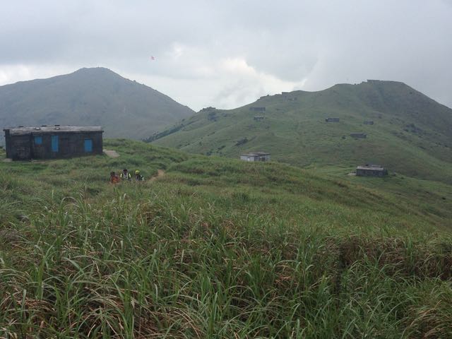
I climbed further towards the clouds and along a broad ridge towards the summit of Sunset Peak. This area has about 20 small stone huts which were built in the 1930s as summer retreats for missionaries to China.
 |
Holiday cottages on Sunset Peak
(looking west to peak) |
In the days before air-conditioning a good way to escape the heat was to come up to the summit here and enjoy the famous mist. There was even a communal dining hall and swimming pool. See this interesting link for some accounts of these huts and the missionaries (
gwulo link).
 |
| Holiday cottages on Sunset Peak (looking east) |
Sunset Peak certainly lived up to its reputation on my visit. As I approached the peak, the mist closed-in, and I was soon walking through cloud with about 10m visibility. I couldn't see anything but I could hear very clearly the roar of Macau ferries as they passed south of Lantau a few km away.
 |
| Steps down from Sunset Peak |
About 200m beyond the summit, the mist cleared and I had a nice view of South Lantau beaches. I could now see the Macau ferries but they were hardly audible out of the cloud.
 |
| Cheung Sha beach from Sunset Peak |
I had lunch around 11:30 on a small side-peak with a good view of the beaches and also Lantau Peak. There was none else about so I briefly took out my shakuhachi and played a very rusty version of 'Kurokami'.
 |
| Lantau Peak from W side of Sunset Peak |
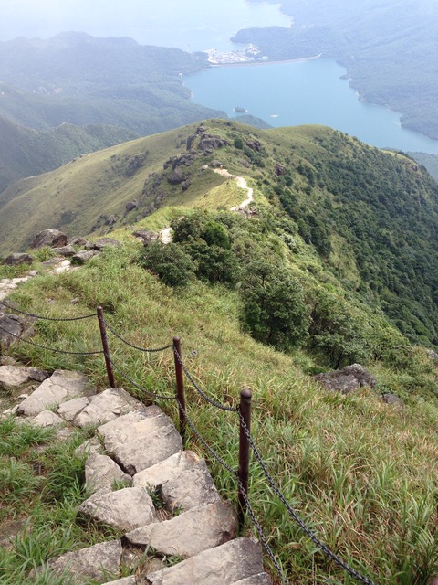
The next part was hard work. A steep descent down stone steps to the pass (333m) losing 500m of altitude, the straight back up gaining 600m height in just 2km of unrelenting stone steps, up to to the top of Lantau peak. It was hot going and I had to stop for a drink every 15min. I was grateful the cloud cover didn't clear.
 |
| Lantau Peak |
It was very happy to get to the top of the peak and enjoy a nice cold drink of coconut water (kept cold by a couple of frozen liter-bottles of water).
 |
| Lantau peak panorama (click to enlarge) |
I stayed on the peak for about 30min to enjoy the view which was clear in all directions except south.
 |
| North from Lantau Peak: Tung Chung and Airport |
Lantau Peak is very steep and you really feel high-up.
 |
South from Lantau Peak: Shek Pik reservoir
and Keung Shan (459m) |
Due to the haze I couldn't see across the Pearl River delta to Macau as I'd hoped. But Nong Ping seemed almost close enough to touch.
 |
West from Lantau Peak: Nong Ping and
Macau Bridge under construction |
I also had a good view of the Hong Kong - Macau bridge being built along the north side of Lantau Island from the Airport out to an artificial island, where it briefly becomes a tunnel, and out to other artificial island and the bridge snaking west across the water into the haze.
 |
| Descent from Lantau Peak |
The path down the west side of the mountain was even steeper than the east side. But the steps are even and well-maintained, and my knees held up well, so I was soon approaching Nong Ping.
 |
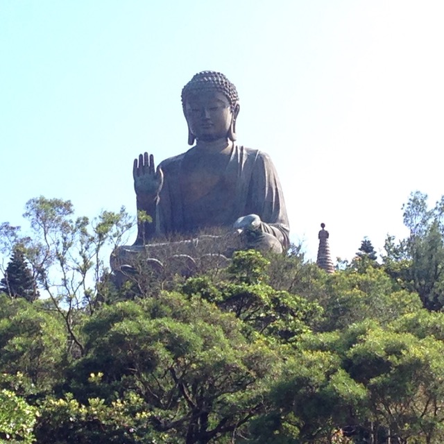
| Nong Ping: Big Buddha and Po Lin monestry |
It was now very sunny and very hot, and I was glad to be near the end of my hike. My shirt was soaked through with sweat and chafing under my arms.
 |
| Tian Tan Big Buddha Statue |
Section 3 of the Lantau Trail finishes underneath Lantau Peak at the 'Wisdom Path', where the Heart Sutra is carved on huge tree-trunks.
 |
| Lantau Peak from Wisdom Path |
Reminiscent of the way sutras used to be written on strips of bamboo. Super-sized, but not out of scale with bulk of the mountain behind.
 |
Wisdom Path: "Sharishi, form is not emptiness
and emptiness is not form" |
I always enjoy going to Nong Ping although I appreciate why some people find it tacky. I even like the big plastic Bodhi tree.
And the big buddha looks as serene as ever.
It was now about 3:30pm, so took the cable car down to Tung Chung and headed home for a bath. I noted that the mist on Sunset Peak had finally burned off in the afternoon sun, and it was completely clear.
 |
| Sunset Peak from Cablecar - no mist! |
Apparently it is a great place to watch the sunset or sunrise, (mist permitting). The best way would be to take your time and hire one of the huts. I wonder if Hannah enjoy that sort of adventure?