Monday, 2 June 2014

Buffalo Hill

For the holiday Monday Rika and Hannah wanted to have a quiet day at home, so I went hiking on my own.


I left around 1:30 and took a taxi across the valley to the village of Siu Lek Yuen.


I wanted to hike east up the hill to the ridge-line between Shatin Valley and Sai Kung / Clearwater Bay.  I thought I'd join section 5 of the Maclehose Trail and go north-west towards Ma On Shan or south-west towards Tates Cairn


It was about 32 degrees and about 60% humidity but nice and shaded for most of the way up.


Looking back west to Fo Tan (the towers of Royal Ascot at the right rear)


I hit the ridge about 2:45 and could have continued over and down through the forest to meet the MacLehose trail (which goes around the outside of Buffalo Hill).   Instead I followed a small track north straight up the hill.   This was tough going in the heat and sun, but there was a nice breeze and I was soon at the summit enjoying magnificent views.  

This is the view from Buffalo Hill (606m) looking south-west towards Lion Rock and Beacon Hill with Lantau Island in the distance.  You can just see the top of ICC poking over the ridge-line (far left)

Looking south-east across Port Shelter and Clearwater Bay

East across Sai Kung Inner Port Shelter

Video Panorama:  View from Buffalo Hill  (south-west-north-south)

I followed the ridge line north-west to another peak (West Bufallo Hill 604m?).    This is the view looking East over Sai Kung with High Island Reservoir and Sai Kung West  Country Park in the distance (far left)
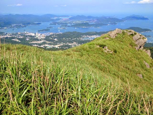

And looking north to Tolo Harbor (below).   From here I could have gone back or taken a path down (east) to join the MacLehose trail.   But I could also see a clear path going north-west down along the ridge-line.  Although it wasn't marked on my map, it was clearly a route down to the road at Mui Tze Lam.  So I confidently set off down the hill through the grass.


I soon ran into an old problem from hiking in NZ when a clear highway in the intended direction branches-off and dwindles to a small track that is probably only used by sheep (or burmese pythons).  

This is the view looking back-up the 'trail' towards Buffalo Hill.   Only a bit of pink plastic tied to some bushes every 200m or so confirmed I was still on the path.   The grass was very thick in places so I felt obliged to proceed with a stompy sort of gait and hope any snakes would wake up and slither away instead of biting my ankles.

I later read in the government safety tips for hiking:   "Common venomous snakes in Hong Kong include Banded Krait, Many-banded Krait, King Cobra, Chines Cobra, Bamboo Snake. They are more active in spring, summer and autumn.   Safety Guidelines:  Wear long trousers and ankle boots.   Use maintained paths, never venture new path and avoid hiking in dense woodland or tall underbrush"  (AFCD link).  


 View north from further along the ridge towards Shek Nga Shan ? (540m)

There were many mountain flowers decorating the route.

I made slow progress down the ridge-line to a steep divide overlooking the Mui Tze Lam valley.  


The other side of the ridge looked down to Siu Lek Yuen from where Id started.  So I headed down that way.  The path was steep and covered by small round rocks like marbles, and I slipped-over repeatedly and lightly sprained both wrists as I broke my fall.  Another reason why sane hikers in HK stick to marked trails.  


The track was quite faint but I followed it down to some old graves by the tree-line and then followed the access track through the forest to the village.  I finished around 5pm and took a mini-bus to Shatin New Town to meet Rika and Hannah for dinner.


Pavilion at the start of the trail between Siu Lek Yuen and Mui Tze Lam.


Precaution against heat-stroke.  I consumed 2.5l in 3hrs with 500ml to spare.


Saturday, 31 May 2014

Royal View Hotel and Lido Beach

This weekend is a long weekend and Rika wanted a change of scene from Royal Ascot by staying overnight somewhere else in Hong Kong.  Since we were booking late, there was little choice and we ended up having to sleep under a bridge.


Of course not just any bridge but the 1,177m Tsing Kau bridge, one of the worlds longest cable-stayed bridges which spans Ramblers Channel from Tsing Yi Island.   Rika had booked us into the Royal View Hotel which is on a headland under the bridge.


The hotel's location offers impressive views of Ramblers Channel, the bottom of the Tsing Kau bridge and also the 1,377m span of the Tsing Ma suspension bridge connecting Tsing Yi to Lantau Island and the Airport.   Although strangely the Hotel actually has no restaurants or bars utilizing these views (these photos are all from the lift lobby).


You can also see Lido Beach just below the bridge


Lido beach doesn't have great water quality.  It was officially 'poor' when we visited (due to recent rains) so we didn't swim.   But there are plenty of trees so you can sit in the shade and enjoy the views.   It also offers beach volleyball - although sadly not while Daddy was there.


Our room faced the other way, overlooking the swimming pool.  On Saturday afternoon Hannah and I played in the pool while Rika relaxed in a lounger.   The pool had a good selection of inflatable crocodiles, sharks and dolphins which Hannah enjoyed falling off.


Unfortunately the pool-side restaurant was closed for a wedding and the other hotel restaurant was already fully-booked when we checked-in.   We didn't want to make a taxi trip to try to find a restaurant in Tsuen Mun so we took the only other option at the hotel and dined in the out-door bar by the hotel entrance.   This was a plane-spotters paradise right under the flight-path to Chek Lap Kok airport and we could watch lots of different aircraft on their final approach.    The food was OK but rather over-priced (HK 1,500 with wine) and Rika woke up at 1am with stomach cramps that she thought was from food poisoning.

On Sunday morning we went down to the beach.


Tsing Kau Bridge from Lido beach at 11am Sunday morning.  It was already about 32 degrees.  
We could watch the great container ships navigating under the Tsing Ma bridge on their way to Guangdong.


 200,000 tons of MSG steaming in to meet China's insatiable demand...


Hannah on the beach at 11am

We had chosen a prime spot.  Two hours later, a large family group set up camp just in front of us.


And the inevitable Aunties relaxing under the trees behind us.


Although we were right under the flight-path to the airport the cicadas in the trees largely drowned-out the sound of the planes.  We frequently had the weird experience of having an aircraft's shadow pass right over us and speed-off across the beach.   There was no food available at the beach so at 2 pm we got hungry and came home.


All and all and interesting trip.  Quite fun to go once but I'm not sure I'd go back.

Saturday, 24 May 2014

Lion Rock Hike

On Saturday Hannah surprised me by asking to go hiking.   So I picked a short (4hr) hike Ive been very keen to do from Tai Wai  to Armah Rock, over Lion Rock and down to Kowloon.  We set off from Tai Wai Station around 2pm with Hannah and about 3l of water in the Deuter.  It was sunny andover 30 degrees.  


The real start of the trail is at the BBQ area at the entrance to Lion Rock Country Park, which we had seen countless times from the motorway to Lion Rock Tunnel.  But finding the access route across the motorway from Tai Wai was surprisingly hard.    Proud Daddy had foolishly left the instructions at home but then found lack of sign-posting defeated his orienteering skills and patience.   Eventually by yomping along various roads in the heat and asking for directions we found the secret crossing on the motorway slip-road leading to the path through the tunnel under the motorway and the hidden staircase to the BBQ area.


At the BBQ area we were greeted by the inevitable group of Aunties having a picnic and a pair of monkeys who were trying to join in.


First part of the hike was up to Armah Rock (Mong Fu Shek), which Hannah walked up quickly.  This 15m rock looks like a woman carrying a baby on her back   I told Hannah the famous Legend about how the woman climbed the hill with her baby every day to look out for her husband who had been sent away to work for an Investment Bank, not knowing that he had died at his desk from overwork.  Eventually in reward for their faithfulness a goddess turned them into a rock (and presumably scaled them up somewhat).  


We couldn't see the view from the rock as the cliff is dangerous and fenced-off.   But it was a good opportunity to show Hannah how the chinese character for 'danger' (3rd from the left in the photo below) is derived from a picture of a dead body at the bottom of a cliff.


For Armah Rock Hannah exercised her right to be carried uphill in the Deuter and we walked up the wooded path towards Lion Rock.  It was now 32 degrees but nice and shaded but we rapidly worked through the bottles of water I'd brought.

This is Shatin valley from the path.


Around 5pm we reached Kowloon Pass just below Lion Rock, and were rewarded by views of Kowloon City.    We finished off the last of the water - 3.5l in 3.5 hours!


The old Kai Tuk airport in Kowloon from Kowloon Pass.


We climbed-up for another 30 min towards the summit of Lion Rock.  Since this is steep and suitable for experienced hikers only I made Hannah dismount from the Deuter, and she happily climbed up.


The views from the top were spectacular.   Looking west along the ridge towards Beacon Hill


Video:  panorama from just below Lion Rock

Hannah just below the 'head' of Lion Rock  

West Kowloon and ICC from Lion Rock


Shek Kip Mei and Beacon Hill from Lion Rock

Video panorama:  view from the 'head' of Lion Rock


Shatin, Fotan and Tolo Harbour from Lion Rock


The path continued on along the lion's 'back' to Tate's Cairn, but it was now about 5:30 and we had to get home so we descended back to Kowloon Pass and took the exit route down to Kowloon.

Lion Rock from the path down to Kowloon from Kowloon Pass.


After about 30min we had defended down to the Lion Rock Park where Hannah still had energy to try out the playground.

Lion Rock  in the late afternoon sun from Lion Rock Park


Monday, 19 May 2014

Postscript: Burmese Python!

When we went camping in Sai Kung West Country park, Rika and Hannah asked me if there would be any snakes.   And I confidently said "No.  Don't worry", and we didn't worry about snakes when we camped in our tent by the bush.

But it turns out that Burmese Pythons, one of the worlds 5 largest largest snakes, live in the park.  And recently, a short distance away from where we camped, at least one giant python has been attacking and killing dogs heavier than Hannah.  


"A pet dog has been crushed to death in front of its owner and her two young children in the second attack by a huge python in Sai Kung West Country Park in less than a fortnight.   Katie Heyring told of how her family pet, Charlie, was killed by the five-metre-long snake as she was out walking near Pak Tam Chung with son Kaspar, five, and daughter Kaia, seven, and their four other dogs on Saturday."    Scmp 19-May-14 (link)


"There have been at least two reported python attacks in recent weeks. Pet owner Courtney Link saved her dog Dexter, which was bitten by a five-metre-long python, by stabbing the snake with a pocket knife."


Dexter with snake bite injury


Charlie was 28kg and Dexter is 24kg vs 21kg for Hannah.

In Quarry Bay, a Burmese python ended up on the promenade, much to residents' alarm, after torrential rains may have washed it down the hillsides. Non-venomous but with a powerful grip, the snake bit a handler in the leg as it was being taken away to a wildlife sanctuary last week".


Sunday, 18 May 2014

May


I was suffering the long-hair blues in the summer heat.  But a trip with Hannah to my favorite QB House in Shinjuku soon fixed that.


Hannah has been making great progress in her climbing class.  I joined her for a family-climbing day on on Sunday afternoon.


After weeks of rain the weather has finally cleared


It has been very hot.  Perfect ice-cream weather.


One weekend I unexpectedly ran into something Id wanted to see for years, and in a most unexpected place.   Times Square in Causeway Bay had an exhibition of the great spanish architect Antoni Gaudi.


I was only at Times Square by accident.  I'd got confused with the World Trade Center where I was supposed to meet Rika for lunch.


Anyway the exhibition was very good.


Model of Sagrada Família (which is being completed with the help of Japanese funding).


Gaudi is famous for building organic (non-standard) shapes.   To ensure that these buildings didn't fall down he had to ensure the loads were appropriately distributed, and avoid unbalanced lateral forces.   This is a fiendishly difficult modeling problem to solve without computers.  


Gaudi solved this in the most ingenious manner by modeling the loads 'upside-down' using chains and weights.  He would create a floor plan and hang chains representing the superstructure of columns and domes.  Weights would represent the weight of the structure.   Under gravity and tension the chains hang in shapes that were perfectly balanced, and could be built in masonry (under compression).


I'd always wanted to see a demonstration of this method, and the exhibition had a huge one with a mirror underneath so you could see the 'building' from 'above'.   But I couldn't get a good photo of it.

There was also a smaller model of a church nave in string.


And turned 'right way up' (below), you can clearly see the pillars, roofline and the nave and isles   The string (hanging under tension) show the lines of force that when built in masonry transmit the compressive loads from the roof down to the floor.


I tried to explain all this to Hannah but since I couldn't rotate the model I had to hang her upside-down from her feet.