We stayed Friday night at a 'Resort Mansion' Mohou in Miura Kaigan. This was a big condominium where you can rent a 40m apartment by the night. It also has a pool in the basement and a big buffet resturant for breakfasts and dinners, and is near the beach.
On Saturday we went down to the beach which looks out east across the bottom of Tokyo Bay to the Boso Peninsiua.
Hannah making friends at the beach.
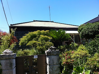
Later on Saturday we went down to Miura to stay at Sugiura-sans holiday house. It is an absolutely lovely 80 year old traditional Japanese house that they have up-dated very sensitively. I was very impressed how pleasant the traditional house is to stay in.
Since it was very hot, I excused myself and went to get my hair cut short at an old barbershop I'd noticed at the end of the road. It was a lovely early-Showa style shop that had been built by the present owner's grandfather in the 1920s. Also it turned out that the barber's hobby was making model ships from scratch, especially ships of the Nihon Yusen line. So we could admire a model of the same liner Hikawamaru that had been moored outside our hotel in Yokohama the previous weekend! He even gave Hannah a ship-in-a-bottle.
Misaki port, the port of Miura town is a major port especially for tuna, although it seemed very quiet when we walked around at dusk. This is looking south-west across Sagami Bay to Mt Amagi in the Izu Peninsula (where Baba's lives). Although the sea was very still when we visited, a few weeks later Misaki was lashed by a typhoon and I heard 2-3 fishermen were drowned.
On Sunday they took us down to the beach on the east side of the peninsula. Hannah could play in the rock pools
Kyo-chan, Rika and Sugiura-san.
The weather was unusually clear and we had spectacular views across Sagami Bay. North-west towards Enoshima, west to Mt Hakone and Mt Fuji, and south-west to Mt Amagi in the Izu peninula.
Between Miura peninsula and Oshima island the Phillipine sea plate is subducting under the Eurasian plate. This lifts up the the Izu, Miura and Boso penisulas on the Eurasian plate, and pushes down the bottom of Sagami bay (max 1500m deep), and also causes regular large megathrust earthquakes. The epicenter of the M7.9 1923 Kanto earthquake which destroyed most of Yokohama and Tokyo is estimate to be just south of the Miura peninsula. In 1703 the same fault ruptured further to the east in the M8.2 Genroku earthquake. (see http://usgsprojects.org/tokyo/submitted/Stein_et_al_Tokyo.pdf). Back in 1498, the M8.6 Meio-Nankaido earthquake caused a large tsunami which caused 26-41,000 casualties and washed away the Kotoku-in temple housing the great buddha in Kamakura.
Looking East to Mt Fuji (in clouds) and Mt Hakone.


1 comment:
Beautiful pictures and memories evoked whilst reading this. Thank you. I used to live near Sagamihara and I am always surprised to see how close it is to Tokyo!
Post a Comment